What equipment did you take...?
Since I returned from my five month long walk, it has always been one of the first questions people make ‘how big and heavy was you rucksack, and what equipment did you take?' I have therefore revisited my notes and listed all the kit I used with the aim to share my experience and views and also hope that this may be of help for others in deciding what to take (or not), and deciding on their own personal kit list, for a weekend or a multi-week adventure. In the next few weeks I hope also to follow this up with how I decided what food to take.
Of course what items we all take (or don’t take) on our trips varies enormously depending on the nature of the trip (location, season, length, environment, facilities) and our individual aspirations, requirements and disposition. It wasn’t easy deciding what to take as I was trying to include equipment which would be suitable for a wide range of situations. An extended solo Scottish summer backpacking trip, with all the vagaries of Scottish highland weather (very hot and very cold), walking in low lying glens but spending a lot of time on Munro tops, crossing rough ground and walking off-track in remote county with some road walking, mostly wild-camping but also using camp sites, often with few facilities, limited backup and several days until possibilities of resupply. A challenge.
There were many factors that eventually shaped the list. One primary factor was pack weight. I wanted as light a pack as possible which meant essential items only. I had to carry this thing over many miles and up 284 hills! If an item wasn’t used, it went home. Saying that, it was supposed to be a holiday and enjoyable and I did make allowances for an acceptable level of comfort.
Walking and camping day after day can take its toll on equipment. I simply couldn’t afford to be constantly buying or replacing gear as needed. I wasn't sponsored by any manufacture however Heather and Alan at Pacerpoles kindly provided my Pacerpoles and Lorraine Macall helped in the supply of my Raichle boots. I also did not have the luxury of immediate backup. If something failed, at best it may have taken days to get a replacement, and at worst, my safety may have been threatened. Any equipment would have to have a certain level of durability built into it.
So with this in mind, I tried to strike a balance between functionality, weight, comfort and durability. The list below shows what I equipment I finally chose to take and carry with me.

Hilleberg Akto Tent
The Akto is so quick and easy to erect I could now put it up blindfold! This was priceless, especially when setting up camp at the end of a very long, tiring day in bad weather or surrounded by swarms of midges. It provided ample space (comfort) for my German Shepherd Dog and me and never showed any signs of weakness in bad weather. Hilleberg are expensive, but after five months of constant use, the tent showed little sign of wear at all.
Golite Pinnacle Rucksack
A simple designed sack and relatively lightweight. I used an Exped waterproof liner within the sack throughout the trip and this never failed to keep everything dry. I found the sack large enough to carry up to six days food (with dog food) although it was at it limits at that. I never considered comfort a problem even though it has no rigid back, padding or mesh. Many of the hills I climbed lightweight by stashing my pack at the bottom of hills between rocks and walking up with just a bumbag filled with safety gear, food and water. I bought the Pinnacle in grey as it camouflaged well into rocks, reducing the risk of it being found while I was away from it. The dog was pretty good at relocating the pack on descent, as it had all her food in! A valuable feature of the Pinnacle are the large mesh side-pockets which are great for allowing ease of access to water bottles, hats, gloves and food bars whilst walking. Again after five months very little sign of significant wear.
Lifeventure Bumbag
I used the bumbag to carry food, water and emergency equipment with me when on forays away from the tent or when I stashed the rucksack.
Rab 400 Quantum Endurance
A superb dependable bag that kept me warm when I needed it. It was unzipped during hot nights and used like a duvet. The outer Endurance fabric was worth its weight in gold as its water repellency helped stop my tent companion (a constantly wet dog) soaking the down! The bag was professionally cleared on my return and the Endurance is as good as it ever was. To prevent the bag getting wet in the pack, it was stuffed into an Exped dry bag and this was placed into the Exped rucksack liner.
Thermarest Prolite 3 (Short)
After a day out on the hills, I never had any problem with sleep, even when it was blowing a hoolie! The Thermarest was very comfortable throughout the trip.
Pacerpoles
Walking poles with ergonomically shaped handles. They eventually became an extension of my limbs and greatly reduced the day to day effort of ascending and descending many hills. These poles played a major role in making the sheer strenuous effort achievable. I would not go out into the hills without them now. Wonderful pieces of equipment!!
Paramo Velez Smock and Cascada Trousers
With the idea of trying to achieve a lightweight flexible clothing system suited to wet, cold and hot weather, I initially packed lightweight Goretex (Berghaus Paclite) clothing and adopted a layering system. When the rain and wind set in during mid-June for six whole weeks, I rapidly sent this clothing home and had my Paramo smock and trousers sent up. The Goretex never lived up to its claims, the jacket and trousers were very delicate (zips, drawcords etc), and a continual on/off with layers eventually became tiring. The Paramo smock and a thin wool top provided a very flexible approach on all but very hot days, where I carried the jacket and swapped the Cascada trousers for thin wind-proofs. They were completely dependable in some very prolonged spells of unpleasant weather and were extremely durable. The Cascada trousers became a bit raggedy on the leg bottoms and inside leg seams, but the smock is in still in excellent condition.
Footwear
I went through five sets of footwear and used Superfeet footbeds.
I initially set off wearing lightweight fabric and Goretex boots (Aku Slope). Although they’re lightweight (which is why I initially bought them), the sole wore out so quickly I was amazed. The second pair were Aku Zeniths, constructed from leather and Goretex. Although they were very, very comfortable, the rubber sole again wore out incredibly quickly indeed. I also used Asolo approach shoes which worked very well. The most miles were walked in a pair of Raichle Mountain Trail boots. They were wonderfully comfortable and waterproof until the sole eventually disintegrated. The final pair were Keen Targhee and immediately felt uber-light compared to the Raichle boots. The Event lining leaked almost as soon as I got them out of the shop and the soles were treacherous on wet grassy slopes!
I like to use Inov8s running shoes when on backpacking trips, but find they can wear out quickly on rough rocky ground. The amount of pairs I would have needed over five months I considered then to be outwith my budget.
MSR Pocket Rocket
This stove is very small, light and simple to use. Disastrously, two months into the trip I found that I could not screw on any gas canisters! I replaced it and the same thing happened towards the end of the trip. I am always careful not to cross thread or over tighten canisters .Maybe these stoves have a working lifespan and I exceeded it?
Terra Nova 2 person Bothy Shelter
I carried this for safety reasons. If required, when away from my rucksack or tent, ‘the dog’ and I could use the shelter to get out of the elements. Taking only a bivvi for emergencies would have excluded shelter to beloved canine companions! It however proved to be very useful for lunch stops in bad weather, sitting on, as a groundsheet and a whole variety of other uses. A very useful bit of gear.
Utility kit
Very small pen knife, pegs, whistle and spare batteries.
First Aid Kit
Compeeds, zinc tape, plaster strips , antiseptic cream, lip salve and paracetamol/ibuprofen.
Hygiene
Wash suds, lightweight towel, toothbrush, toothpaste, loo roll, lighter and hand sanitiser.
.JPG)


.JPG)

.JPG)
.JPG)

.JPG)
.JPG) One Monday morning about nine, we found ourselves alongside Loch Fannich (looking like a mirror) in marvelous conditions. Thinking about what I may have been doing on a such a morning, it made me really aware about how lucky I was to be doing this walk.
One Monday morning about nine, we found ourselves alongside Loch Fannich (looking like a mirror) in marvelous conditions. Thinking about what I may have been doing on a such a morning, it made me really aware about how lucky I was to be doing this walk..JPG) Glen Beg Bothy - outside...
Glen Beg Bothy - outside....JPG) ...and inside! All my wet clothes drying over this fantastic potbellied stove.
...and inside! All my wet clothes drying over this fantastic potbellied stove..JPG) Red deer were rutting and roaring by the time I reached the Beinn Dearg hills. They also were not phased by people and dogs. This one was most untroubled by how close were came.
Red deer were rutting and roaring by the time I reached the Beinn Dearg hills. They also were not phased by people and dogs. This one was most untroubled by how close were came..JPG) The run up to the end. Ben Hope in distance.
The run up to the end. Ben Hope in distance. And then reunited with the support pack spending a week on Raasay 1 stone in weight lighter!
 Skye doingng her best Sphinx impression on Lochnagar
 Another pose beside Loch Avon in the heart of the Cairngorms. It was so hot we nearly got a suntan!
 An idyllic wildcamp at Loch nan Cnapan around 850 metres.
 These really were days in the mountains that were spectacular. Here was a view from Braeriach on a very hot calm day. Skye scrubbed a paw on descent into Aviemore so it was an unscheduled rest for a couple of days and a trip to the vets to make sure all our six feet were OK.
 The weather broke after Aviemore so it was into the Monadhliath in low cloud and rain. Here was a wonderful wildcamp under Creag Meagaidh at around 900metres.
 Onwards and westwards into Knoydart. This was taking as we were ascending Gairich.
 Knoydart... one of my favourite areas of Scotland.
 .JPG)
 A very hot sweaty walk along the south Glen Shiel ridge ending with the saddle shown here in the distance. Nine Munros on that day- a long one!
 Then we headed west towards Skye. This was taken as we were approaching Blaven. Impressive looking mountain and the start of that gabbro rock. Goodbye fingertips!
 The Skye Cuillin could have been a big sticking point of the walk. At my limits I managed to complete them all, and then the Inn pin with the help of Simon Webb and Paul Glading in awful weather. Thanks guys !
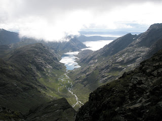 The view from An Dorus on the ridge. Stunning...no explanation needed.
 An unexpected visitor on the summit cairn of Sgurr Alasdair.


 Skye, the natural poser on Beinn a Chochuill with Cruachan in the background.


 This is one of my favourite bothies - Meananach in Glen Nevis. It kept us dry during a particulalry nasty storm...Thanks Mountain Bothies Association.


